Climbing maps II. | New functions |
 We introduced new maps two month ago and today we are going to bring a great number of new functionalities.
If you haven’t see these maps yet check the article, which is linked below.
Our maps are pretty progressing because since we started (two month ago) we added 291 new points of interests (more than half are new rocks).
(Wanna thank for this contribution mainly to V.Vinduška (61 new points) and J. Burian (12 new points).
We will appreciate if you would send us also your measured points.
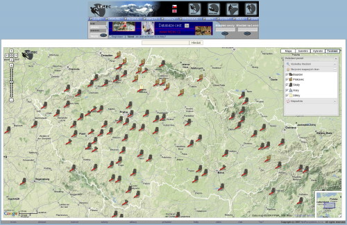
You have often commented a small view of map field. We added a button "Upper map size" means Fit the map to the whole screen.
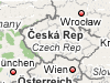
View of the whole republic (resolution 1600x1200)
Again there is a button ("Terrain"), which will give you for mountaineers a very pleasant view - a mountain terrain view.
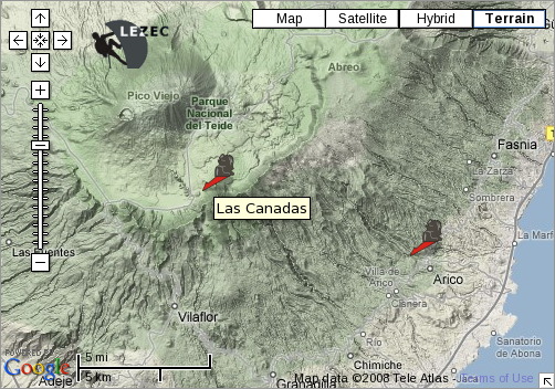
Tenerife, and the Spain’s highest peak Pico de Teide (3717 m)
Good spot where you can leave your car is visible in deep zoom in level.
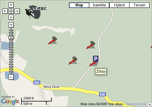
See a parking place icon
All information concerning climbing spot is provided by an info bubble, which is also equipped with a full text search features.
English article available
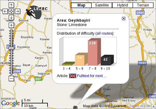
Info bubble helps to identify the area even if you are too close and see just the tiny sectors. Just clicking on the name of the whole area you can get a big picture of it.
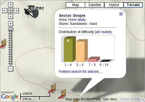
See in the upper part of the bubble an area "Arrea: Horní skály"
We tried to tune all processes to maximize the speed of data download.
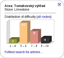
We have changed grade range graphs, now we got intervals 1-4, 5-6, 7-8, 9-10.
We have expressed the status that just a latest browsers will be supported though we tried to implement the functionality also for older versions.
BTW, today is release day of Firefox in version 3.0.
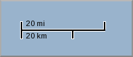
Its just a little thing but it helps to have a big picture concerning distances.
New functions will be continued, point will be more bounded with guidebooks and Tune it to be better tool for planning trips.
Our maps are pretty progressing because since we started (two month ago) we added 291 new points of interests (more than half are new rocks).
(Wanna thank for this contribution mainly to V.Vinduška (61 new points) and J. Burian (12 new points).
We will appreciate if you would send us also your measured points.
The whole page view
You have often commented a small view of map field. We added a button "Upper map size" means Fit the map to the whole screen.
Terrain view
Again there is a button ("Terrain"), which will give you for mountaineers a very pleasant view - a mountain terrain view.
Parking place
Good spot where you can leave your car is visible in deep zoom in level.
Full text search and top rated articles
All information concerning climbing spot is provided by an info bubble, which is also equipped with a full text search features.
View of the area
Info bubble helps to identify the area even if you are too close and see just the tiny sectors. Just clicking on the name of the whole area you can get a big picture of it.
Speed
We tried to tune all processes to maximize the speed of data download.
Grade Range
We have changed grade range graphs, now we got intervals 1-4, 5-6, 7-8, 9-10.
Browsers
We have expressed the status that just a latest browsers will be supported though we tried to implement the functionality also for older versions.
BTW, today is release day of Firefox in version 3.0.
Distance ruler
Its just a little thing but it helps to have a big picture concerning distances.
Bright future
New functions will be continued, point will be more bounded with guidebooks and Tune it to be better tool for planning trips.
| Lezec.cz [edit] | 21:46 17.06.2008 |
Commentaries | ... | new comments | New comment  |
| coordinates | 12:25:44 25.06.2008 |
| Hello, very nice new maps feature! Would it be possible to get a list with coordinates of all areas to use in my navigation? like this: country_name-are_climbingstyle_coordinates LU Berdorf sandstone 49.8316;6.34426 | |
| petje | reply |
| Re: coordinates | 15:16:15 14.07.2008 | |
| Hi Petje, we are going to incorporate such a feature into coming version of our map system. So in the final version you should be able download a list of all spots for climbing on the globe. Now we are about to fill in the database of points so it takes some time so please be patience. | ||
| Jirka S | reply | |